<?xml version="1.0" encoding="UTF-8" standalone="no"?><?xml-stylesheet type="text/xsl" href="/metadata/stylesheets/datasets/extern/metadata.xsl"?><MD_Metadata xmlns="http://www.isotc211.org/2005/gmd" xmlns:gco="http://www.isotc211.org/2005/gco" xmlns:gml="http://www.opengis.net/gml" xmlns:gmx="http://www.isotc211.org/2005/gmx" xmlns:gts="http://www.isotc211.org/2005/gts" xmlns:srv="http://www.isotc211.org/2005/srv" xmlns:xlink="http://www.w3.org/1999/xlink" xmlns:xsi="http://www.w3.org/2001/XMLSchema-instance" xsi:schemaLocation="http://www.isotc211.org/2005/gmd http://schemas.opengis.net/iso/19139/20060504/gmd/gmd.xsd http://www.isotc211.org/2005/gmx http://schemas.opengis.net/iso/19139/20060504/gmx/gmx.xsd">
		<fileIdentifier>
			<gco:CharacterString>accf5f80-a8e7-49b4-8778-11e55734d953</gco:CharacterString>
		</fileIdentifier>
		<language>
			<LanguageCode codeList="http://www.loc.gov/standards/iso639-2/php/code_list.php" codeListValue="dut" codeSpace="ISO639-2">dut</LanguageCode>
		</language>
		<characterSet>
			<MD_CharacterSetCode codeList="http://www.isotc211.org/2005/resources/Codelist/gmxCodelists.xml#MD_CharacterSetCode" codeListValue="utf8" codeSpace="ISOTC211/19115">utf8</MD_CharacterSetCode>
		</characterSet>
		<hierarchyLevel>
			<MD_ScopeCode codeList="http://www.isotc211.org/2005/resources/Codelist/gmxCodelists.xml#MD_ScopeCode" codeListValue="dataset" codeSpace="ISOTC211/19115">dataset</MD_ScopeCode>
		</hierarchyLevel>
		<hierarchyLevelName>
			<gco:CharacterString>dataset</gco:CharacterString>
		</hierarchyLevelName>
		<contact>
			<CI_ResponsibleParty>
				<individualName>
					<gco:CharacterString>team Data, Informatie, GIS en Innovatie</gco:CharacterString>
				</individualName>
				<organisationName>
					<gco:CharacterString>Provincie Overijssel</gco:CharacterString>
				</organisationName>
				<positionName>
					<gco:CharacterString>beheerder</gco:CharacterString>
				</positionName>
				<contactInfo>
					<CI_Contact>
						<address>
							<CI_Address>
								<deliveryPoint>
									<gco:CharacterString>Postbus 10078</gco:CharacterString>
								</deliveryPoint>
								<city>
									<gco:CharacterString>Zwolle</gco:CharacterString>
								</city>
								<administrativeArea>
									<gco:CharacterString>Overijssel</gco:CharacterString>
								</administrativeArea>
								<postalCode>
									<gco:CharacterString>8000 GB</gco:CharacterString>
								</postalCode>
								<country>
									<gco:CharacterString>NL</gco:CharacterString>
								</country>
								<electronicMailAddress>
									<gco:CharacterString>kennishub@overijssel.nl</gco:CharacterString>
								</electronicMailAddress>
							</CI_Address>
						</address>
						<onlineResource>
							<CI_OnlineResource>
								<linkage>
									<URL>https://www.overijssel.nl</URL>
								</linkage>
							</CI_OnlineResource>
						</onlineResource>
					</CI_Contact>
				</contactInfo>
				<role>
					<CI_RoleCode codeList="http://www.isotc211.org/2005/resources/Codelist/gmxCodelists.xml#CI_RoleCode" codeListValue="custodian" codeSpace="ISOTC211/19115">custodian</CI_RoleCode>
				</role>
			</CI_ResponsibleParty>
		</contact>
		<dateStamp>
			<gco:Date>2025-12-10</gco:Date>
		</dateStamp>
		<metadataStandardName>
			<gco:CharacterString>ISO 19115</gco:CharacterString>
		</metadataStandardName>
		<metadataStandardVersion>
			<gco:CharacterString>Nederlands metadata profiel op ISO 19115 voor geografie 2.0.0</gco:CharacterString>
		</metadataStandardVersion>
		<spatialRepresentationInfo>
			<MD_VectorSpatialRepresentation>
				<topologyLevel>
					<MD_TopologyLevelCode codeList="http://www.isotc211.org/2005/resources/Codelist/gmxCodelists.xml#MD_TopologyLevelCode" codeListValue="geometryOnly" codeSpace="ISOTC211/19115">geometryOnly</MD_TopologyLevelCode>
				</topologyLevel>
				<geometricObjects>
					<MD_GeometricObjects>
						<geometricObjectType>
							<MD_GeometricObjectTypeCode codeList="http://www.isotc211.org/2005/resources/Codelist/gmxCodelists.xml#MD_GeometricObjectTypeCode" codeListValue="composite" codeSpace="ISOTC211/19115">composite</MD_GeometricObjectTypeCode>
						</geometricObjectType>
					</MD_GeometricObjects>
				</geometricObjects>
			</MD_VectorSpatialRepresentation>
		</spatialRepresentationInfo>
		<spatialRepresentationInfo>
			<MD_VectorSpatialRepresentation>
				<topologyLevel>
					<MD_TopologyLevelCode codeList="http://www.isotc211.org/2005/resources/Codelist/gmxCodelists.xml#MD_TopologyLevelCode" codeListValue="geometryOnly" codeSpace="ISOTC211/19115">geometryOnly</MD_TopologyLevelCode>
				</topologyLevel>
				<geometricObjects>
					<MD_GeometricObjects>
						<geometricObjectType>
							<MD_GeometricObjectTypeCode codeList="http://www.isotc211.org/2005/resources/Codelist/gmxCodelists.xml#MD_GeometricObjectTypeCode" codeListValue="composite" codeSpace="ISOTC211/19115">composite</MD_GeometricObjectTypeCode>
						</geometricObjectType>
					</MD_GeometricObjects>
				</geometricObjects>
			</MD_VectorSpatialRepresentation>
		</spatialRepresentationInfo>
		<referenceSystemInfo>
			<MD_ReferenceSystem>
				<referenceSystemIdentifier>
					<RS_Identifier>
						<code>
							<gco:CharacterString>https://www.opengis.net/def/crs/EPSG/0/https://www.opengis.net/def/crs/EPSG/0/28992</gco:CharacterString>
						</code>
						<codeSpace>
							<gco:CharacterString>EPSG</gco:CharacterString>
						</codeSpace>
						<version>
							<gco:CharacterString>4.5(8.0.1)</gco:CharacterString>
						</version>
					</RS_Identifier>
				</referenceSystemIdentifier>
			</MD_ReferenceSystem>
		</referenceSystemInfo>
		<identificationInfo>
			<MD_DataIdentification>
				<citation>
					<CI_Citation>
						<title>
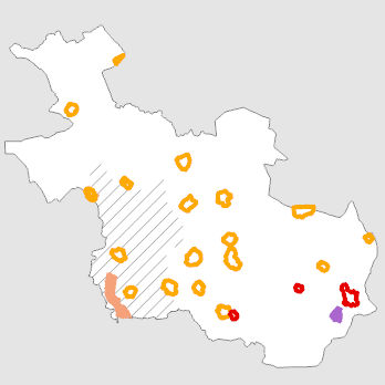
							<gco:CharacterString>Grondwaterbeschermingsgebieden</gco:CharacterString>
						</title>
						<alternateTitle>
							<gco:CharacterString>B3.grwbes_polygon (B3/B34)</gco:CharacterString>
						</alternateTitle>
						<date>
							<CI_Date>
								<date>
									<gco:Date>1998-06-08</gco:Date>
								</date>
								<dateType>
									<CI_DateTypeCode codeList="http://www.isotc211.org/2005/resources/Codelist/gmxCodelists.xml#CI_DateTypeCode" codeListValue="creation" codeSpace="ISOTC211/19115">creation</CI_DateTypeCode>
								</dateType>
							</CI_Date>
						</date>
						<date>
							<CI_Date>
								<date>
									<gco:Date>2025-05-27</gco:Date>
								</date>
								<dateType>
									<CI_DateTypeCode codeList="http://www.isotc211.org/2005/resources/Codelist/gmxCodelists.xml#CI_DateTypeCode" codeListValue="publication" codeSpace="ISOTC211/19115">publication</CI_DateTypeCode>
								</dateType>
							</CI_Date>
						</date>
						<date>
							<CI_Date>
								<date>
									<gco:Date>2025-04-16</gco:Date>
								</date>
								<dateType>
									<CI_DateTypeCode codeList="http://www.isotc211.org/2005/resources/Codelist/gmxCodelists.xml#CI_DateTypeCode" codeListValue="revision" codeSpace="ISOTC211/19115">revision</CI_DateTypeCode>
								</dateType>
							</CI_Date>
						</date>
						<edition>
							<gco:CharacterString>april 2025</gco:CharacterString>
						</edition>
						<identifier>
							<MD_Identifier>
								<code>
									<gco:CharacterString xlink:href="">c26245a7-aa99-4032-9c22-4dd57b239a3a</gco:CharacterString>
								</code>
							</MD_Identifier>
						</identifier>
						<presentationForm>
							<CI_PresentationFormCode codeList="http://www.isotc211.org/2005/resources/Codelist/gmxCodelists.xml#CI_PresentationFormCode" codeListValue="mapDigital" codeSpace="ISOTC211/19115">mapDigital</CI_PresentationFormCode>
						</presentationForm>
						<presentationForm>
							<CI_PresentationFormCode codeList="http://www.isotc211.org/2005/resources/Codelist/gmxCodelists.xml#CI_PresentationFormCode" codeListValue="mapDigital" codeSpace="ISOTC211/19115">mapDigital</CI_PresentationFormCode>
						</presentationForm>
					</CI_Citation>
				</citation>
				<abstract>
					<gco:CharacterString>Grondwaterbeschermingsgebieden zijn gebieden direct rondom drinkwaterwinningen aangewezen op grond van de Wet ruimtelijke ordening en de Wet milieubeheer. In deze gebieden wordt het grondwater beschermd, zowel ruimtelijk als milieutechnisch. Uitgangspunt van het beschermingsbeleid is preventie, het voorkomen van risicovolle activiteiten. Een ander uitgangspunt is het voorzorgsprincipe. Nieuwe risicovolle activiteiten worden uit voorzorg verboden of slechts onder voorwaarden toegestaan. Met de term grondwaterbeschermingsgebied wordt de zone aangeduid die zich uitstrekt van het waterwingebied (60-dagenzone) tot de 25-jaarszone. De buitenste grens is gebaseerd op een verblijftijd van het grondwater van 25 jaar in het watervoerend pakket voordat het wordt opgepompt voor drinkwaterwinning. De grens is gelegd langs in het veld herkenbare grenzen. De waterwingebieden, grondwaterbeschermingsgebieden en boringsvrije zones worden gezamenlijk aangeduid als milieubeschermingsgebieden met de functie waterwinning (zie gerelateerde datasets). Boringsvrije zones zijn aangewezen om verontreiniging van diepe grondwaterlagen te voorkomen.</gco:CharacterString>
				</abstract>
				<purpose>
					<gco:CharacterString>basisdata</gco:CharacterString>
				</purpose>
				<status>
					<MD_ProgressCode codeList="http://www.isotc211.org/2005/resources/Codelist/gmxCodelists.xml#MD_ProgressCode" codeListValue="completed" codeSpace="ISOTC211/19115">completed</MD_ProgressCode>
				</status>
				<pointOfContact>
					<CI_ResponsibleParty>
						<individualName>
							<gco:CharacterString>team Data, Informatie, GIS en Innovatie</gco:CharacterString>
						</individualName>
						<organisationName>
							<gco:CharacterString>Provincie Overijssel</gco:CharacterString>
						</organisationName>
						<positionName>
							<gco:CharacterString>beheerder</gco:CharacterString>
						</positionName>
						<contactInfo>
							<CI_Contact>
								<address>
									<CI_Address>
										<deliveryPoint>
											<gco:CharacterString>Postbus 10078</gco:CharacterString>
										</deliveryPoint>
										<city>
											<gco:CharacterString>Zwolle</gco:CharacterString>
										</city>
										<administrativeArea>
											<gco:CharacterString>Overijssel</gco:CharacterString>
										</administrativeArea>
										<postalCode>
											<gco:CharacterString>8000 GB</gco:CharacterString>
										</postalCode>
										<country>
											<gco:CharacterString>NL</gco:CharacterString>
										</country>
										<electronicMailAddress>
											<gco:CharacterString>kennishub@overijssel.nl</gco:CharacterString>
										</electronicMailAddress>
									</CI_Address>
								</address>
								<onlineResource>
									<CI_OnlineResource>
										<linkage>
											<URL>https://www.overijssel.nl</URL>
										</linkage>
									</CI_OnlineResource>
								</onlineResource>
							</CI_Contact>
						</contactInfo>
						<role>
							<CI_RoleCode codeList="http://www.isotc211.org/2005/resources/Codelist/gmxCodelists.xml#CI_RoleCode" codeListValue="owner" codeSpace="ISOTC211/19115">owner</CI_RoleCode>
						</role>
					</CI_ResponsibleParty>
				</pointOfContact>


				<resourceMaintenance>
					<MD_MaintenanceInformation>
						<maintenanceAndUpdateFrequency>
							<MD_MaintenanceFrequencyCode codeList="http://www.isotc211.org/2005/resources/Codelist/gmxCodelists.xml#MD_MaintenanceFrequencyCode" codeListValue="annually" codeSpace="ISOTC211/19115">annually</MD_MaintenanceFrequencyCode>
						</maintenanceAndUpdateFrequency>
					</MD_MaintenanceInformation>
				</resourceMaintenance>
				<graphicOverview>
					<MD_BrowseGraphic>
						<fileName>
							<gco:CharacterString>https://metadata.geodataoverijssel.nl/attachment/237058/grwbes_polygon.jpg</gco:CharacterString>
						</fileName>
					</MD_BrowseGraphic>
				</graphicOverview>
				<descriptiveKeywords>
					<MD_Keywords>
						<keyword>
							<gco:CharacterString>grondwater</gco:CharacterString>
						</keyword>
						<keyword>
							<gco:CharacterString>grondwaterbeschermingsgebieden</gco:CharacterString>
						</keyword>
						<keyword>
							<gco:CharacterString>grondwaterkaarten</gco:CharacterString>
						</keyword>
						<keyword>
							<gco:CharacterString>waterwingebieden</gco:CharacterString>
						</keyword>
						<keyword>
							<gco:CharacterString>waterwinning</gco:CharacterString>
						</keyword>
						<keyword>
							<gco:CharacterString>provinciale milieuverordening</gco:CharacterString>
						</keyword>
						<keyword>
							<gco:CharacterString>provinciale verordeningen</gco:CharacterString>
						</keyword>
						<thesaurusName>
							<CI_Citation>
								<title>
									<gco:CharacterString>Thesaurus van Overijssel</gco:CharacterString>
								</title>
								<date>
									<CI_Date>
										<date>
											<gco:Date>2019-01-10</gco:Date>
										</date>
										<dateType>
											<CI_DateTypeCode codeList="http://www.isotc211.org/2005/resources/Codelist/gmxCodelists.xml#CI_DateTypeCode" codeListValue="publication" codeSpace="ISOTC211/19115">publication</CI_DateTypeCode>
										</dateType>
									</CI_Date>
								</date>
							</CI_Citation>
						</thesaurusName>
					</MD_Keywords>
				</descriptiveKeywords>
				
				<resourceConstraints><MD_Constraints><useLimitation><gco:CharacterString>Geen gebruiksbeperkingen</gco:CharacterString></useLimitation><useLimitation><gco:CharacterString>Geoportaal extern</gco:CharacterString></useLimitation><useLimitation><gco:CharacterString>Downloadable data</gco:CharacterString></useLimitation></MD_Constraints></resourceConstraints><resourceConstraints>
					<MD_LegalConstraints>
						<accessConstraints>
							<MD_RestrictionCode codeList="http://www.isotc211.org/2005/resources/Codelist/gmxCodelists.xml#MD_RestrictionCode" codeListValue="otherRestrictions" codeSpace="ISOTC211/19115">otherRestrictions</MD_RestrictionCode>
						</accessConstraints>
						<otherConstraints>
							<gco:CharacterString>http://creativecommons.org/publicdomain/zero/1.0/deed.nl</gco:CharacterString>
						</otherConstraints><otherConstraints>
							<gco:CharacterString>Geen beperkingen</gco:CharacterString>
						</otherConstraints>
					</MD_LegalConstraints>
				</resourceConstraints>
				<aggregationInfo>
					<MD_AggregateInformation>
						<aggregateDataSetName>
							<CI_Citation>
								<title>
									<gco:CharacterString>Layerfile: https://geo.overijssel.nl/geoportaal/lyr/nlam_gwbg.lyrx</gco:CharacterString>
								</title>
								<date gco:nilReason="missing"/>
							</CI_Citation>
						</aggregateDataSetName>
						<associationType gco:nilReason="missing"/>
					</MD_AggregateInformation>
				</aggregationInfo>
				<spatialRepresentationType>
					<MD_SpatialRepresentationTypeCode codeList="http://www.isotc211.org/2005/resources/Codelist/gmxCodelists.xml#MD_SpatialRepresentationTypeCode" codeListValue="vector" codeSpace="ISOTC211/19115">vector</MD_SpatialRepresentationTypeCode>
				</spatialRepresentationType>
				<spatialResolution>
					<MD_Resolution>
						<equivalentScale>
							<MD_RepresentativeFraction>
								<denominator>
									<gco:Integer>10000</gco:Integer>
								</denominator>
							</MD_RepresentativeFraction>
						</equivalentScale>
					</MD_Resolution>
				</spatialResolution>
				<language>
					<LanguageCode codeList="http://www.loc.gov/standards/iso639-2/php/code_list.php" codeListValue="dut" codeSpace="ISO639-2">dut</LanguageCode>
				</language>
				<characterSet>
					<MD_CharacterSetCode codeList="http://www.isotc211.org/2005/resources/Codelist/gmxCodelists.xml#MD_CharacterSetCode" codeListValue="utf8" codeSpace="ISOTC211/19115">utf8</MD_CharacterSetCode>
				</characterSet>
				<topicCategory>
					<MD_TopicCategoryCode>boundaries</MD_TopicCategoryCode>
				</topicCategory>
				<topicCategory>
					<MD_TopicCategoryCode>planningCadastre</MD_TopicCategoryCode>
				</topicCategory>
				<environmentDescription>
					<gco:CharacterString>Microsoft Windows 10 Version 10.0 (Build 19045) ; Esri ArcGIS 13.2.2.49743</gco:CharacterString>
				</environmentDescription>
				<extent>
					<EX_Extent>
						<geographicElement>
							<EX_GeographicBoundingBox>
								<westBoundLongitude>
									<gco:Decimal>5.985</gco:Decimal>
								</westBoundLongitude>
								<eastBoundLongitude>
									<gco:Decimal>7.073</gco:Decimal>
								</eastBoundLongitude>
								<southBoundLatitude>
									<gco:Decimal>52.208</gco:Decimal>
								</southBoundLatitude>
								<northBoundLatitude>
									<gco:Decimal>52.792</gco:Decimal>
								</northBoundLatitude>
							</EX_GeographicBoundingBox>
						</geographicElement>
						<geographicElement>
							<EX_GeographicDescription>
								<geographicIdentifier>
									<MD_Identifier>
										<code>
											<gco:CharacterString xlink:href="">Provincie Overijssel</gco:CharacterString>
										</code>
									</MD_Identifier>
								</geographicIdentifier>
							</EX_GeographicDescription>
						</geographicElement>
					</EX_Extent>
				</extent>
			</MD_DataIdentification>
		</identificationInfo>
		<contentInfo>
			<MD_FeatureCatalogueDescription>
				<includedWithDataset>
					<gco:Boolean>false</gco:Boolean>
				</includedWithDataset>
				<featureTypes>
					<gco:LocalName>B3.grwbes_polygon</gco:LocalName>
				</featureTypes>
				<featureCatalogueCitation gco:nilReason="missing"/>
			</MD_FeatureCatalogueDescription>
		</contentInfo>
		<distributionInfo>
			<MD_Distribution>
				<distributionFormat>
					<MD_Format>
						<name>
							<gco:CharacterString>SDE Feature Class</gco:CharacterString>
						</name>
						<version>
							<gco:CharacterString>10.0</gco:CharacterString>
						</version>
					</MD_Format>
				</distributionFormat>
				<distributor>
					<MD_Distributor>
						<distributorContact>
							<CI_ResponsibleParty>
								<individualName>
									<gco:CharacterString>team Data, Informatie, GIS en Innovatie</gco:CharacterString>
								</individualName>
								<organisationName>
									<gco:CharacterString>Provincie Overijssel</gco:CharacterString>
								</organisationName>
								<positionName>
									<gco:CharacterString>beheerder</gco:CharacterString>
								</positionName>
								<contactInfo>
									<CI_Contact>
										<address>
											<CI_Address>
												<deliveryPoint>
													<gco:CharacterString>Postbus 10078</gco:CharacterString>
												</deliveryPoint>
												<city>
													<gco:CharacterString>Zwolle</gco:CharacterString>
												</city>
												<administrativeArea>
													<gco:CharacterString>Overijssel</gco:CharacterString>
												</administrativeArea>
												<postalCode>
													<gco:CharacterString>8000 GB</gco:CharacterString>
												</postalCode>
												<country>
													<gco:CharacterString>NL</gco:CharacterString>
												</country>
												<electronicMailAddress>
													<gco:CharacterString>kennishub@overijssel.nl</gco:CharacterString>
												</electronicMailAddress>
											</CI_Address>
										</address>
										<onlineResource>
											<CI_OnlineResource>
												<linkage>
													<URL>https://www.overijssel.nl</URL>
												</linkage>
											</CI_OnlineResource>
										</onlineResource>
									</CI_Contact>
								</contactInfo>
								<role>
									<CI_RoleCode codeList="http://www.isotc211.org/2005/resources/Codelist/gmxCodelists.xml#CI_RoleCode" codeListValue="distributor" codeSpace="ISOTC211/19115">distributor</CI_RoleCode>
								</role>
							</CI_ResponsibleParty>
						</distributorContact>
					</MD_Distributor>
				</distributor>
				<transferOptions>
					<MD_DigitalTransferOptions>
						<unitsOfDistribution>
							<gco:CharacterString>Overijssel</gco:CharacterString>
						</unitsOfDistribution>
						
					<onLine><CI_OnlineResource><linkage><URL>https://www.geoportaaloverijssel.nl/metadata/dataset/accf5f80-a8e7-49b4-8778-11e55734d953</URL></linkage><protocol><gco:CharacterString>UKST</gco:CharacterString></protocol></CI_OnlineResource></onLine><onLine><CI_OnlineResource><linkage><URL>https://download.geoportaaloverijssel.nl/download/vector/accf5f80-a8e7-49b4-8778-11e55734d953</URL></linkage><protocol><gco:CharacterString>landingpage</gco:CharacterString></protocol></CI_OnlineResource></onLine><onLine><CI_OnlineResource><linkage><URL>https://services.geodataoverijssel.nl/viewer/layer/B34_beheer_grondwater/B3_Grondwaterbeschermingsgebieden</URL></linkage><protocol><gco:CharacterString>landingpage</gco:CharacterString></protocol></CI_OnlineResource></onLine><onLine><CI_OnlineResource><linkage><URL>https://services.geodataoverijssel.nl/geoserver/B34_beheer_grondwater/wfs</URL></linkage><protocol><gco:CharacterString>OGC:WFS</gco:CharacterString></protocol><name><gco:CharacterString>B3_Grondwaterbeschermingsgebieden</gco:CharacterString></name></CI_OnlineResource></onLine><onLine><CI_OnlineResource><linkage><URL>https://www.geoportaaloverijssel.nl/metadata/service/d27f077b-d471-4778-8591-820bbbd1b127</URL></linkage><protocol><gco:CharacterString>UKST</gco:CharacterString></protocol></CI_OnlineResource></onLine><onLine><CI_OnlineResource><linkage><URL>https://services.geodataoverijssel.nl/geoserver/B34_beheer_grondwater/wms</URL></linkage><protocol><gco:CharacterString>OGC:WMS</gco:CharacterString></protocol><name><gco:CharacterString>B3_Grondwaterbeschermingsgebieden</gco:CharacterString></name></CI_OnlineResource></onLine><onLine><CI_OnlineResource><linkage><URL>https://www.geoportaaloverijssel.nl/metadata/service/5ece94e9-c489-4b96-8775-fa8ee0dd9318</URL></linkage><protocol><gco:CharacterString>UKST</gco:CharacterString></protocol></CI_OnlineResource></onLine></MD_DigitalTransferOptions>
				</transferOptions>
			</MD_Distribution>
		</distributionInfo>
		<dataQualityInfo>
			<DQ_DataQuality>
				<scope>
					<DQ_Scope>
						<level>
							<MD_ScopeCode codeList="http://www.isotc211.org/2005/resources/Codelist/gmxCodelists.xml#MD_ScopeCode" codeListValue="dataset" codeSpace="ISOTC211/19115">dataset</MD_ScopeCode>
						</level>
					</DQ_Scope>
				</scope>
				<lineage>
					<LI_Lineage>
						<statement>
							<gco:CharacterString>Provincie Overijssel</gco:CharacterString>
						</statement>
						<processStep>
							<LI_ProcessStep>
								<description>
									<gco:CharacterString>Bij besluit van PS op 16 april 2025 is boringsvrije zone Salland Diep Noord toegevoegd.</gco:CharacterString>
								</description>
							</LI_ProcessStep>
						</processStep>
					</LI_Lineage>
				</lineage>
			</DQ_DataQuality>
		</dataQualityInfo>
	<dataQualityInfo><DQ_DataQuality><scope><DQ_Scope><level><MD_ScopeCode codeList="./resources/codeList.xml#MD_ScopeCode" codeListValue="dataset">dataset</MD_ScopeCode></level></DQ_Scope></scope><lineage><LI_Lineage><processStep><LI_ProcessStep><description><gco:CharacterString>INHOUD ATTRIBUTENTABEL: OBJECTID: Uniek identificatienummer binnen dit bestand. NAAM: Naam van het grondwaterbeschermingsgebied CODE: 1 grondwaterbeschermingsgebied; 2 nitraatgevoelig grondwaterbeschermingsgebied; 3 grondwaterbeschermingsgebied, uitsluitend verbod op diepe boring; LEGENDA: Area of feature in internal units squared. DIEPTE: Area of feature in internal units squared. KWO: gebied waar koude-warmte opslag niet is toegestaan, of tot een bepaalde diepte BUITEN: Gelegen binnen of buiten de provincie Overijssel (1=buiten, 0 = binnen) INNAMEZONE: gebied van de innamezone waterwinning SALL_DIEP: gebied van het diepe pakket van Salland NR_GRWBES: Nummer van het grondwaterbeschermingsgebied. SHAPE: Geometrie van het object.</gco:CharacterString></description><processor><CI_ResponsibleParty><role><CI_RoleCode codeList="./resources/codeList.xml#CI_RoleCode" codeListValue="processor"/></role></CI_ResponsibleParty></processor></LI_ProcessStep></processStep></LI_Lineage></lineage></DQ_DataQuality></dataQualityInfo></MD_Metadata>